Apartments in Buenos Aires
Find an apartment for your stay!


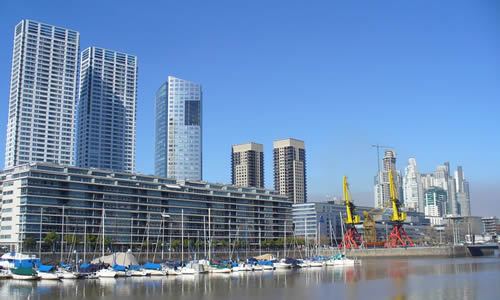
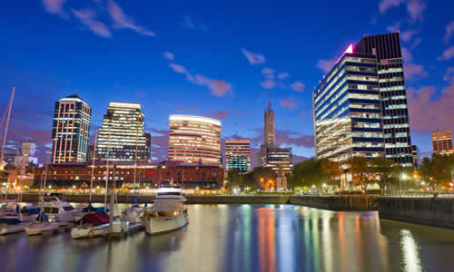
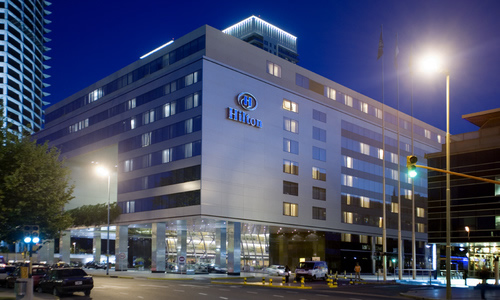
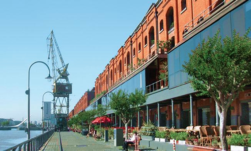
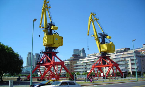
| Buenos Aires is a city next to the water. So what about the “barrio” that’s right on the water, Puerto Madero? You won’t find an area less like Buenos Aires anywhere else in Buenos Aires. Occupying a significant portion of the Río de la Plata riverbank and representing the latest architectural trends in the city, Puerto Madero is the “new” district and one of the most expensive. Its position next to the city center, its modern constructions, its luxury hotels and its fancy restaurants make of it one of the most special of the capital. Puerto Madero was originally a port. Odd enough though it was only a functioning port for about fifteen years after it was finished in 1897. It was built to accommodate the cargo ships of the day, but the increasing use of larger cargo ships around that time quickly rendered it obsolete. The New Port of Buenos Aires was completed in 1926, making the existing Madero docks superfluous. Though these continued to serve in ancillary port functions, the zone gradually decayed, becoming one of the city's most degraded areas, a mixture of warehouses and large tracts of undeveloped land. Successive proposals were put forth with the intent of urbanizing the old port, or to demolish it outright. None of these plans came to fruition until November 15th, 1989, when the Ministry of Works and Public Services, the Department of the Interior and the City of Buenos Aires signed the acts of incorporation of a joint-stock company denominated "Corporación Antiguo Puerto Madero", having as objective the urbanization of the area. The signed agreement implied the transference of the totality of the area (170 hectares) to the Old Puerto Madero Corporation S.A., whereas the government of the city remained in charge of the urban development regulations. In the 1990s, local and foreign investment led to a massive regeneration effort, recycling and refurbishing the west side warehouses into elegant houses, offices, lofts, private universities, luxurious hotels and restaurants that conform to a gallery of options for this new district in a city that grew up turning its back to the river. Led by the 1999 opening of the Hilton Buenos Aires, luxurious hotels, state-of-the-art multiplex cinemas, theatres, cultural centres, and office and corporate buildings are located mostly in the east side. Every street in Puerto Madero is named after women. Puerto Madero currently represents the largest urban renewal project in the city of Buenos Aires. Having undergone an impressive revival in merely a decade, it is one of the most successful recent waterfront renewal projects in the world. |
|
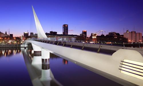
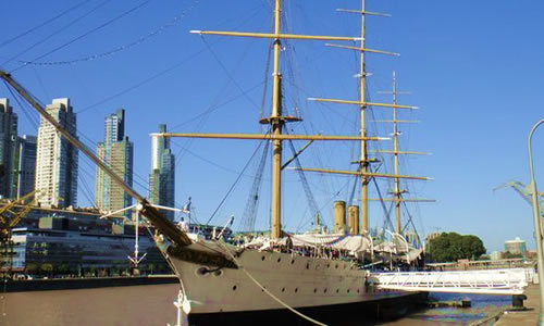
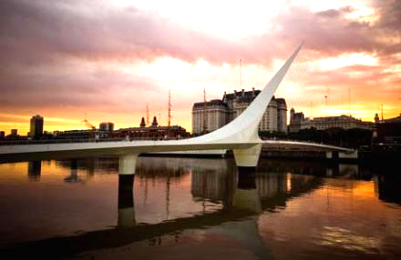
Puente de la mujer: "Woman's Bridge" - Unique sights in Puerto Madero include the distinctive “Puente de la Mujer”, which spans Dique 3 and is a beautifully modern pedestrian bridge supposed to represent a synthesis of a couple dancing the tango. Designed by Santiago Calatrava, this 160m long pedestrian rotates 90° to allow water traffic to pass. Started in 1998, it was inaugurated on December 20th, 2001, and is the only one of Calatrava's works in Latin America. Fragata Sarmiento: ARA Presidente Sarmiento museum ship - Open everyday from 10 am to 7 pm (Address: Dique 3). Elegant 85m steamer originally built in England in 1897 as a training ship for the Argentine Navy and named after Domingo Faustino Sarmiento, the seventh President of Argentina. It is the first training ship of the Argentine navy. It made thirty seven annual training cruises including six circumnavigations of the globe. The ship was retired as a seagoing vessel in 1938, but continued to serve as a stationary training ship until 1961. It is now maintained in her original 1898 appearance as a museum ship. It is considered to be the last intact cruising training ship from the 1890s. www.ara.mil.ar Corvette ARA Uruguay: Open everyday from 9 am to 7 pm (Address: Dique 4). The corbeta (corvette) ARA Uruguay, built in England, is the largest ship afloat of its age in the Armada de la República Argentina (Argentine Navy), with more than 135 years passed since its commissioning in September 1874. The last of the legendary squadron of President Sarmiento, the Uruguay took part in revolutions, ransoms, expeditions, rescues, and was even floating headquarters of the Navy School. During its operational history 18741926 the Uruguay was agunboat, school ship, expedition support ship, Antarctic rescue ship, fisheries base supply ship, and hydrographic survey vessel. The Uruguay was dismissed from service in 1926 (with 52 years of naval service), to become a floating ammunition dump. In 1954 the Uruguay was rebuilt in the Río Santiago Shipyard, and, in 1967, it was declared a National Historic Landmark and integrated as a museum ship with the frigate ARA Presidente Sarmiento in the Museum of Sea and Navigation. www.ara.mil.ar Museo de la inmigración: Open from Thuesday to Sunday from 11 am to 7 pm. (Address: Avenida Antártida Argentina, 1355 - between Dirección Nacional de Migraciones and Buquebus). This museum tells the history of thousands of Europeans which have arrived in Buenos Aires since the 1880s. untref.edu.ar/muntref/museo-de-la-inmigracion |
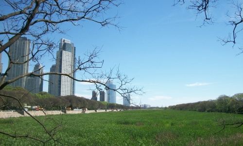
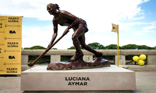
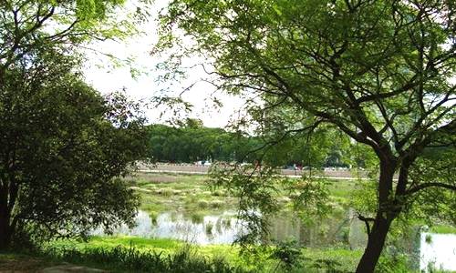
La reserva ecológica de Buenos Aires: Buenos Aires Ecological Reserve - Open from 8 am to 7 pm from November to March and from 8 am to 6 pm from April to October (Address: av. Tristán Achaval Rodríguez, 1550). The ecological reserve is a gigantic green space which extends over 350 hectares (3,5 km²). In the early 1970s, a new project which consisted of reclaiming land from the river in front of the old “Costanera Sur” Riverside Resort was created. The land-filling started in 1978 using the Dutch “polder” system; embankments were built using debris from demolitions carried out to construct urban motorways. Land-filling and debris dumping went on discontinuously until 1984, when works were finally ended. Since then, different plant communities developed spontaneously from seeds present in the silt, windborne or dispersed by the animals. By providing refuge and food, plants helped animal populations to settle in. As the biological diversity increased, woods and a variety of animal species appeared. The official recognition occurred on June 5th, 1986, when the Buenos Aires City Council voted unanimously the Ordinance 41,247 granting protection to the area, thus echoing the claims of the Non-Governmental Organizations. Being adjacent to the city, a visit to the Ecological Reserve is an escape from the hustle and bustle of the metropolis. A number of trails leading to the river are perfect for birdwatching, strolling, cycling and nature lovers. Costanera Sur: (Address: Intendente Noel & Intendente Giralt Avenues). Costanera Sur (South Waterfront) is an old waterfront promenade. It functioned as a public riverside resort until the 1980's when was created the Buenos Aires Ecological Reserve, losing forever its function. The boardwalk is a wide path with a wall with stairs that lead to a lower level. During the 1920s, many breweries and restaurants faced the resort, and some of its buildings designed by Hungarian architect Andrés Kalnay survive recycled. Currently there are many casual eateries, small food stands where you can eat “choripan” and “bondiola” sandwiches (pork meat), among other foods. El Paseo de la Gloria: The “walk of glory” was created within the framework of the preparation of the 2018 Youth Olympic Games in Buenos Aires. Located all along Costanera Sur, from the ecological reserve until Belgrano Avenue, it shows 10 sculptures designed by the artist Carlos Benavídez and to pay tribute to the most prominent Argentine athletes: Luciana Aymar, Gabriela Sabatini, Guillermo Vilas, Manu Ginóbili, Lionel Messi, Diego Maradona, Juan Manuel Fangio… |